Visitor Questions
The address is 90 Congress Avenue, Rochester, NY 14619.
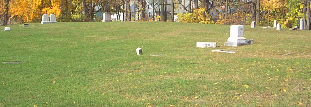
In its prime, the cemetery featured many more headstones and other artifacts related to roadways, burial plots and maintenance. The current trees did not exist. The surrounding orchards gave way to housing developments in the early decades of the Twentieth Century.
The cemetery has some elevations and depressions that impede wheelchair access and make mobility difficult for persons with walkers. All visitors should enter the cemetery at its west side to avoid the sloped terrace. Bench seating is minimal. There are no paved pathways in the cemetery, only dirt.
No, visitors must use Genesee Street commercial business restrooms located about a seven minute walking distance from the cemetery.
NO. This technique is forbidden in Rochester-area cemeteries. The process causes damage to the fragile headstone surface. Photography and digital imaging are welcome.
Yes. A small box is hidden somewhere on the cemetery grounds. The originator is unknown. Enjoy the exploration and discovery process. Return the box to its location.
Rapids Cemetery is about a mile from the bicycle trailhead junction in Genesee Valley Park that links the Erie Canalway, Genesee Valley Greenway and the City of Rochester’s Riverway Trails.
Make a detour westward from the Riverway bicycle trail at the Brooks Landing pedestrian bridge. (Brooks Avenue and South Plymouth Avenue). Proceed one-third mile southward along Genesee Street to 90 Congress Avenue.
Toppled undisturbed trees created the conditions for the establishment of wild black raspberry bushes. These heritage organic specimens are now cultivated. Youth volunteers harvest the fruit which is donated to local St. Peter’s Kitchen.
History Questions
Rapids Cemetery is named after the nearby pioneer Rapids settlement located at today’s Brooks Landing (Brooks Avenue at Genesee Street). Glacial deposits of boulders at this Genesee River location created cataracts resulting in non-navigable shallow fast-flowing waters.
It is two hundred years old. It was incorporated in 1818 but land acquisition from the Wadsworth family of Geneseo took place several years earlier.
Early records indicate that it is about 1.5 acres. The accessible flat cemetery surface area today is roughly the size of a football field. The northern slope needs further reclamation.
The elevation provides good soil drainage in a formerly marshy area. The flat surface is part of a glacial moraine (accumulated soil and rock deposits from a glacier). It is perhaps the highest location in southwest Rochester.
Rapids Cemetery was originally within the town borders of Gates. The City of Rochester annexed this land in 1874 as it expanded outwards with trolley service.
A cemetery map created by Isaac Loomis and updated in 1881 lists individual or family burial plots. Surveys done generations ago by the Daughters of the American Revolution add further detail. Current genealogical research continues.
The cemetery has a mix of civilian and military burials. Veterans from the Revolutionary War, War of 1812, Civil War and possibly the Spanish-American War are interred here. The true number of burials is unknown due to limited surviving records of actual burials.
Rapids Cemetery includes laborers, barrel-makers (coopers), inn and tavern keepers, carpenters, blacksmiths, seamstresses, domestic servants, washerwomen, architects, a chairmaker, a whip-maker, a police constable, a lawyer and even a Justice of the Peace.
No. Each has a separate burial plot in the Victorian-style municipal Mt. Hope Cemetery noted for its design by the famed Olmsted landscape architecture family.
A local hero of the War of 1812, Captain Daniel Loomis is buried here along with his extended family. Lesser-known burials are persons whose names are memorialized in local street names (Brooks, Thurston, Ballintine).
Several founding members of the church are buried here. Originally known as Rapids Baptist Church, it began as a mission to minister to the needs of the Rapids settlement. The area was considered rowdy with several taverns and there was occasional conflict among the residents.
Some were farmers but many were canal boatmen for the Genesee Valley Canal that ran parallel to the Genesee River at this site. Others were teamsters who off-loaded and transported river cargo by wagon to the early downtown Rochester settlement.
The rich wheat-producing farmland in southwest Rochester also supported extensive floral and fruit tree nurseries. An apple orchard bordered the cemetery in its early days. At the time of the Erie Canal relocation, circa 1920, there was crude temporary worker housing in the area.
Many residents of Rapids settlement were very poor and many had no family locally. They were likely buried in a simple fabric shroud with no casket or headstone. The Potter’s Field segment of Rapids Cemetery occupies the southwest border along the sidewalk.
Rapids settlement was populated with young migrants from elsewhere in the US and immigrants to America fleeing harsh economic conditions and wars. Many died young from disease with no family to remember them.
Diseases claimed many lives. Today’s medicines, antibiotics and sanitation were not available then. Epidemics like cholera and malaria (known as “Genesee Fever”) caused death. Many young women died due to complications at or after childbirth.
Rochesterians joined the 13th New York Volunteer Infantry, 108th NYVI and 140th NYVI. The 108th and 140th NYVI trained at Camp FitzJohn Porter about a mile north of Rapids Cemetery along the Genesee River near Flint Street. Veterans from other regiments are buried here also.
All the Civil War gravestones at Rapids Cemetery are Government-Issued replacements added in the 1960s at the time of the Civil War Centennial.
Susan B. Anthony lived at her father’s family farm near today’s Brooks Avenue and Genesee Park Blvd. She lived here during her Temperance, Abolition and Women’s Rights periods from 1840 until 1865. She then moved to Madison Street in Rochester.
There are identified Underground Railroad locations in southwest Rochester. Abolitionist Frederick Douglass visited the Anthony family farm. Nineteenth Ward resident Asa Anthony, a distant cousin of Susan, helped freedom-seekers find refuge. Further research is needed.
Spanish-American War veteran Frederick Peiffer is actually buried at Mt. Hope Cemetery. The headstone at Rapids Cemetery is a duplicate that lacks key dates. Its placement here is a mystery. Several other headstone pieces have migrated somewhat from their original positions.
Many of the Rapids settlement residents were poor and could not afford headstones. Some grave markers, over time, had sunk into the ground. Many were vandalized. Some were removed to create a playing field by neighborhood youth.
A professional Ground-Penetrating Radar (GPR) flat terrain scan performed in 2016 identified only one headstone. Careful manual soil-probing since 2016 uncovered about ten subsurface headstones. A few artifacts might still be hidden along the northern sloped border.
The last known burial was William L. King in 1941. The cemetery had become overgrown and neglected around 1910. Many neighbors were surprised at that time that a cemetery even existed there.
The citizens who founded the private cemetery corporation had moved or passed away by 1910. Neither the County nor the City assumed cemetery ownership. It grew significantly wild for over one hundred years. The City of Rochester now controls and maintains the grounds.
Rapids settlement is older than the Rochesterville settlement of 1811. Location of the Erie Canal aqueduct in the 1820s at Nathaniel Rochester’s One Hundred Acres plot drew economic development and population growth two miles northward. Rapids settlement never recovered.
Restoration Questions
Back in 2015 the 19th Ward Community Association responded to requests from local veterans groups to restore the cemetery. Over 100 neighborhood, college, civic and youth group members have contributed since then with practical assistance from the City of Rochester.
This group began in 2015 and includes the 19th Ward History & Archives group, City of Rochester Historian, neighbors and local veterans who research, consult and plan the cemetery restoration processes.
The 19th Ward Community Association’s History & Archives Group worked over a 2-year period with Rochester Institute of Technology undergraduate teams in order to create this self-guided tour. Under the direction of Professors Stephen Zilora and Mike Zink, the members of the team whose project was selected for implementation are: Clayton Brimm, Brett Phillips, Jonathan Aurit, Robert O’Connell, Sven Kopun, and Niko Jugovac. The project was handed over in 2020 to a different team of RIT undergrad students overseen by Jessica Lieberman including: Marissa Burkland, Andrew England, and Michele Fensken.
Weeds, vines and wild “volunteer” vegetation covered the sloped areas. Wild growth was eradicated by manual effort. Scouting groups restored lawn surfaces by covering the bare weed-free earth with layers of cardboard, mulch and topsoil to block root regrowth.